

Somalia Backs UN ‘Correct the Map’ Resolution as 164 Nations Overwhelmingly Approve New World Map
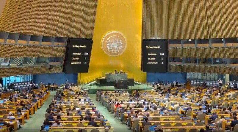
UNITED NATIONS — Somalia joined 163 other nations in voting to adopt an African-led resolution calling for a shift away from the centuries-old Mercator projection toward maps that more accurately represent the true size of continents, with only the United States voting against and six nations abstaining.
The resolution, formally designated A/80/L.104 and introduced by Togo on behalf of the African Group, promotes the use of equal-area projections including the Equal Earth map. The campaign challenges the Mercator projection, developed in 1569 by Flemish cartographer Gerardus Mercator, which dramatically enlarges areas near the poles while shrinking equatorial regions. Africa is actually about 14 times larger than Greenland, though the Mercator map makes them appear comparable in size.
“A fair world begins with a fair map,” Togo’s Foreign Minister Robert Dussey told the General Assembly, arguing that the resolution “has to do with cognitive justice, with access to precise geographical knowledge, the dignity of peoples, historic memory.”
A Victory for Africa’s Diplomatic Voice
The vote represents a significant diplomatic victory for Africa, coming just months after Somalia was elected to a non-permanent seat on the UN Security Council with 179 votes in the General Assembly. The African Union adopted the Equal Earth map in February, and Togo subsequently took the initiative to the UN, with informal consultations held in July before Friday’s vote.
For Somalia, which secured a position on the African Union Peace and Security Council for the first time since 2003 in February 2026, the resolution aligns with its broader diplomatic resurgence. The country also holds a non-permanent seat on the UN Security Council for the 2025-2026 term and assumed the rotating presidency of the Council in January 2026 for the first time since 1972.
“Africa, once diminished on maps, now insists on being seen at its true scale – geographically, historically, morally, culturally, economically, diplomatically and globally,” said Amma Twum-Amoah, commissioner for the AU’s Department of Health, Humanitarian Affairs and Social Development.
The Distortion and Its Consequences
The UN resolution notes “with concern that this distortion contributes to minimizing the perceived sizes of Africa, Latin America and South Asia, and perpetuating an unbalanced view of the world.” It further warns that distortions “contribute to minimizing the extent of socio-economic realities, infrastructure needs, development potential and prosperity in the regions of the South, and that they can fuel biases in environmental, geopolitical and security areas.”
African leaders have linked the campaign to confronting colonial-era legacies, with Dussey stating that the Mercator map’s widespread use is “a consequence of colonisation.” The resolution also relates the initiative to the Pact for the Future, approved by UN member states in 2024, which calls for action to address historical and structural inequalities.
France announced it would abandon the Mercator projection, with Foreign Minister Jean-Noël Barrot stating that “the time has come to correct them.”
US Stands Alone in Opposition
The United States was the only country to vote against the resolution. US Ambassador to the UN Mike Waltz criticized the initiative, saying Washington viewed it not as a neutral attempt to correct cartographic distortions but as part of a broader “radical ideological project.”
“The United States clearly sees it cannot be separated from the much larger and more radical ideological project it belongs to,” Waltz said. He argued that the resolution was a distraction from “genuine problems of international peace, prosperity or good relations” and described such measures as “barnacles on our work here and the reason this institution is losing its credibility.”
Among the six abstaining countries were Ukraine, Estonia, Georgia, Lithuania, Moldova, and Serbia. Ukraine’s UN envoy Andriy Melnyk explained his country’s abstention, citing concerns that the Equal Earth projection depicted “parts of Ukraine’s territory that have been temporarily occupied by Russia … in a manner that is wholly unacceptable.”
Critical Note
The overwhelming support for the “Correct the Map” resolution represents a significant diplomatic moment for Africa, and for Somalia as a key voice on the continent. The lopsided 164-1 vote suggests that many nations see the cartographic campaign not as trivial, but as a meaningful symbolic confrontation with colonial-era legacies that continue to shape global perceptions.
For Somalia, which has long challenged external narratives imposed on the Horn of Africa, the resolution aligns with its broader diplomatic stance. The country has consistently rejected colonial-era boundaries and representations that diminished Somali territories, and this resolution represents another front in that struggle. However, the resolution’s impact will ultimately depend on whether schools, publishers, international organizations, and major mapping services like Google Maps actually adopt the Equal Earth standard. Togo’s plan to revise its own textbooks offers a test case for whether this initiative moves beyond a symbolic UN vote into classrooms around the world.
Recommended Reading On ftlsomalia.com
Credit: Source link