

China’s Qaidam Basin shaken by M6.3 earthquake

想閱讀本文的中文版本(由Google自動翻譯),請點擊這裡。
Can you help? We are working to make earthquake science accessible to the public, but this effort is entirely supported by readers like you. If you can, please consider supporting our work by upgrading to a paid subscription. If you use our Substack as part of a group, or for teaching, consider a teaching or institutional subscription. Every paid subscription makes a real difference — and unlocks access to the more than three hundred posts in our archive!
On June 16, 2026, a magnitude 6.3 earthquake struck the northern border of China’s Qaidam Basin, in the northern part of the Tibetan Plateau. The USGS estimates that some areas close to the epicenter experienced intensity VIII shaking (severe), and news reports indicate that at least one person was killed. Nevertheless, as of this writing, only a single felt report has been received by the USGS, and none by the EMSC.
This is likely for two reasons.
First, very few people live here. This is a remote, arid, mountainous region. Elevations here start at 2700 meters (~8,800 feet). The mountains top out above 5000 meters (~16,400 feet). What precipitation does fall drains internally, leaving saline lakes in the valleys.
Nevertheless, there are a few population centers. Chaidan Town, population ~8,000, is located just a few kilometers from the epicenter.
This wiki for Chaidan Town includes several Chinese-language videos; one of these pans over a 3D model of the town, which appears to be a planned and highly urbanized community with substantial concrete buildings.
We have never visited Chaidan Town, but the wiki describes it evocatively: “its main characteristics are dryness, coldness, frequent sandstorms, indistinct seasons, and long winters. The annual average temperature is 1.3°C, and the annual precipitation is 85.9 millimeters.” The town seems to exist largely to support mining. Its name, “Chaidan,” is Mongolian for “salt lake.”
Chaidan Town is notable because it is the only town that we can identify within 50 kilometers of the epicenter.
The USGS PAGER system estimates that 8,000 people may have experienced VIII shaking; we assume is the recorded population of Chaidan Town. Perhaps the wiki entry should be edited to read “dryness, coldness, frequent sandstorms, indistinct seasons, long winters, and infrequent but violent earthquake shaking.” We assume that it is this population of 8,000 that contributes to their estimated fatalities, since the next level of estimated shaking is only intensity V.
Because we do not have any felt reports from Chaidan Town and the USGS does not report any seismometers nearby, we cannot confirm the shaking intensities that were actually experienced, but the fact that at least one death has been reported indicates that damage occurred.
This lack of information highlights the second reason for the lack of reports: information about earthquakes in China is not effectively shared outside of China. We usually see very low rates of reporting to organizations in the US and Europe from China — perhaps due to a combination of language and cultural barriers, and government/internet controls. We know that information is collected within the country, but those reports are not provided in an accessible way to people outside the country, or at least not in a way that we are familiar with. It is very likely that China has a number of seismometers proximal to this earthquake; China’s seismology practice is very advanced.
What we do know is that the area of estimated intensity VIII shaking (severe) is quite small, so any errors in earthquake location by the USGS could significantly affect the estimated shaking at this location. The USGS reports an uncertainty of ±7.9 kilometers horizontally for the M6.3 earthquake. Furthermore, the actual shaking intensity estimates are based on assumptions about the earthquake behavior and the ground structure. And, the calculated intensities at Chaidan Town seem to be between 7.5 and 8 — rounded up to VIII. It is certainly possible that the intensities in Chaidan Town were closer to intensity VII (very strong). Both levels of shaking can cause building damage, but at different scales. An ordinary well-built building will typically see slight to moderate damage at intensity VII shaking, but can be severely damaged at intensity VIII.
In addition to shaking, there were likely landslides in the steep terrain northeast of Chaidan Town. Here is the estimated landslide map from the USGS.
If any of our readers are aware of seismometer recordings, shaking reports, or information about damage in this earthquake, please let us know in the comments!
The earthquake occurred at the border between the Qaidam Basin and the Qilian Shan Mountains. The Qaidam Basin is a high-elevation “basin” within the northern part of the Tibetan Plateau; the Qilian Shan lie to its north.
The map below shows the whole plateau. On top of topography, we have plotted black arrows with measurements from GPS stations (data from GSRM; Kreemer et al., 2014), showing the movement of the crust year-over-year relative to stable Eurasia.
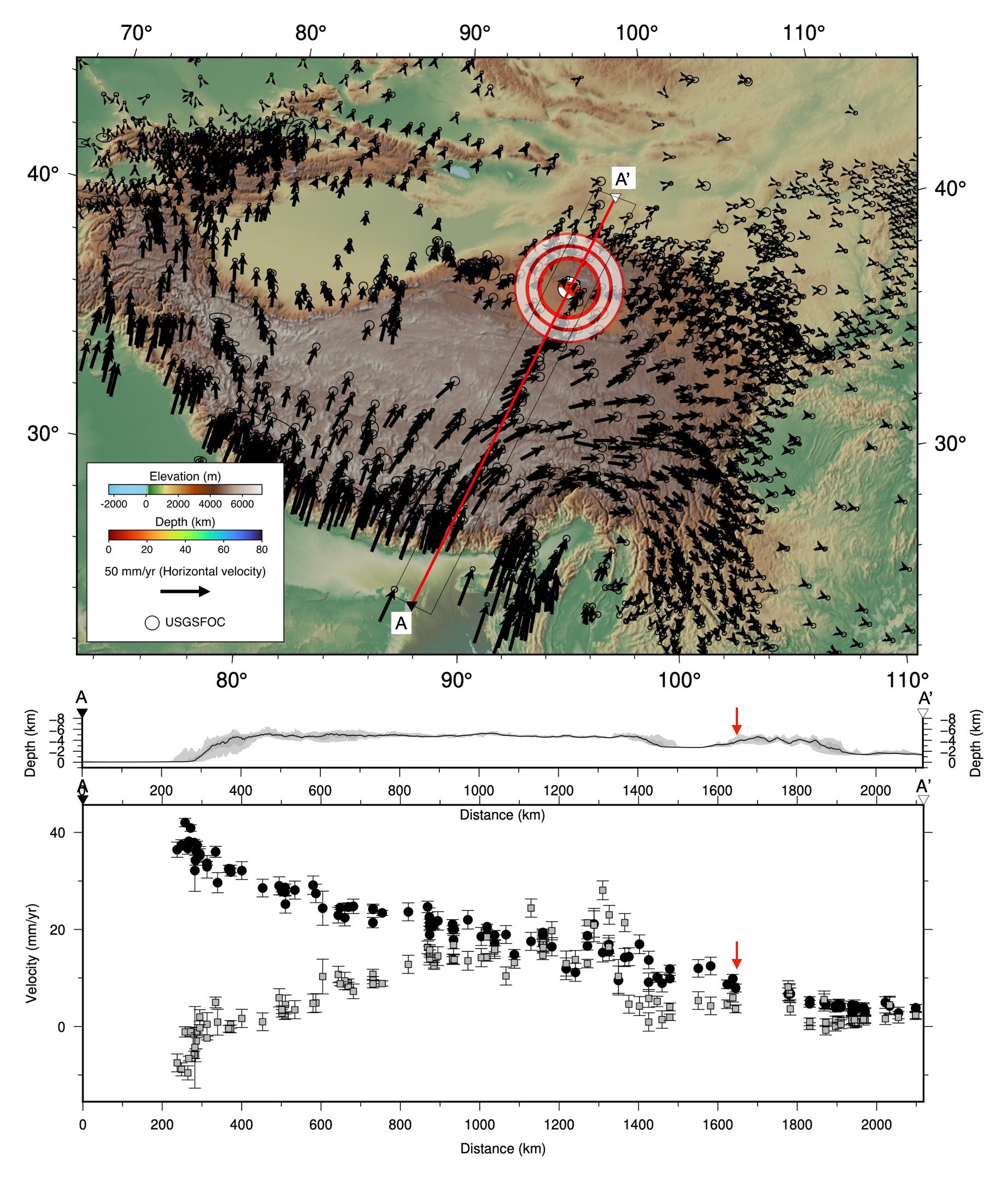
The Tibetan Plateau exists because of the ongoing collision between India and Eurasia, which started 50 million years ago (after the intervening ocean basin subducted away). Today, GPS shows that each year, India moves another ~40 millimeters northward.
That collision has produced some of the most impressive tectonic features on Earth, and it continues to be responsible for earthquakes across this entire region, spanning thousands of kilometers. It also has reshaped climate patterns by intruding upward into the atmosphere and redirecting the monsoon, and is thought to be responsible for large-scale decreases in atmospheric carbon dioxide and therefore global cooling. The idea is that the uplift and erosion of so much crustal material accelerated silicate weathering, which uses up CO2. The plateau is a really big deal (so to speak).
Among the more minor effects of this tremendous process is the recent M6.3 earthquake that occurred in the northern part of the plateau. Below the map we have drawn two profiles: one of elevation, the other of the GPS data. The black circles show movement to the north; the gray squares movement towards the east. The progressive trend in the black circles from left to right demonstrates that shortening of the plateau is being accommodated broadly across the entire system. The earthquake occurred as part of this much larger crustal shortening.
The east-west motion (the gray squares) highlight a whole different type of behavior in response to the collision: eastward extrusion of the central part of the plateau. The whole plateau is cut across by vast strike-slip faults that carry long slivers of crust away from the ‘bulldozer’ that is India. There are also large normal faults developing in response to this east-west motion. We’ve written about these structures before, for instance, after the deadly M7.1 earthquake that struck southern Tibet in 2025.
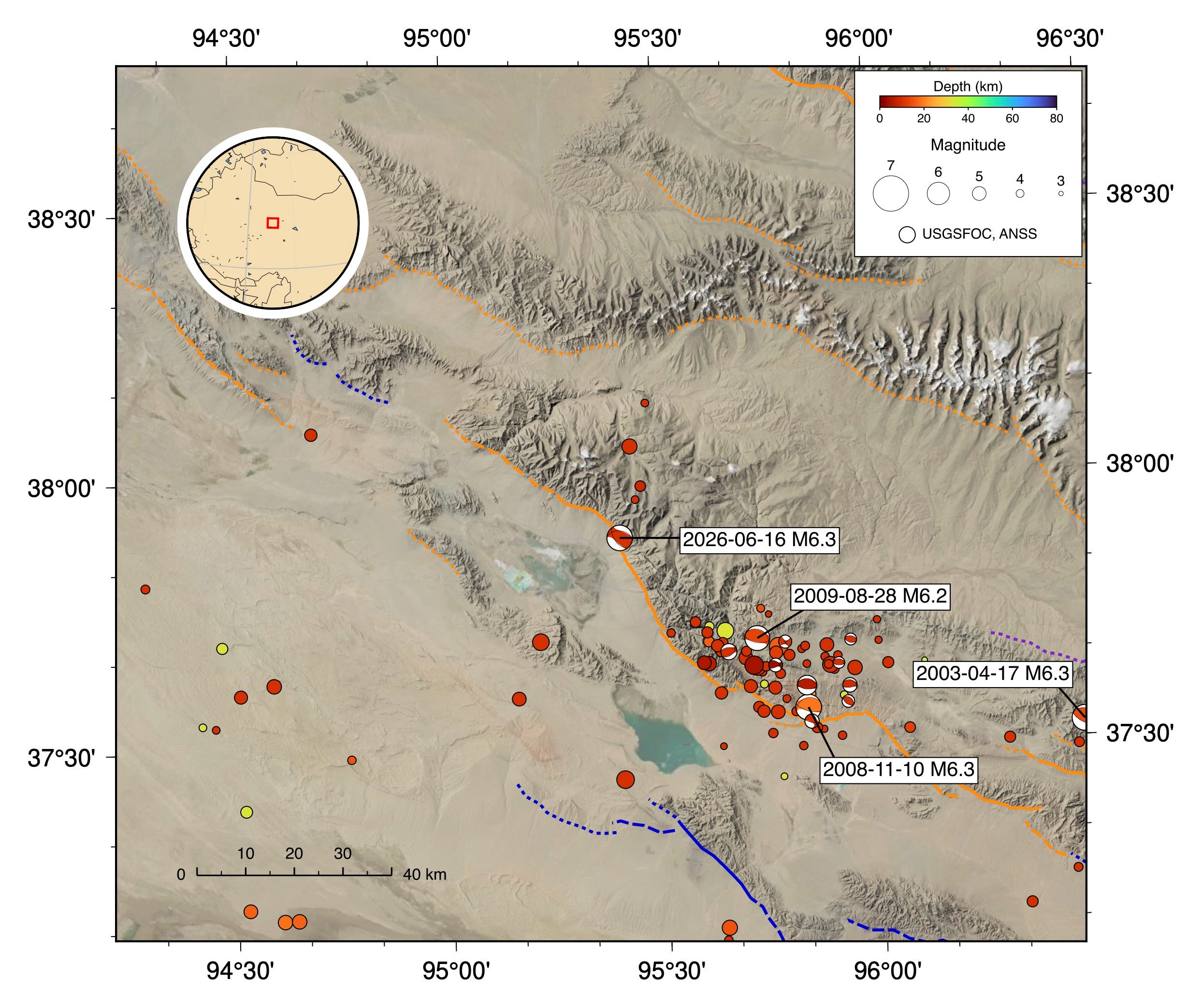
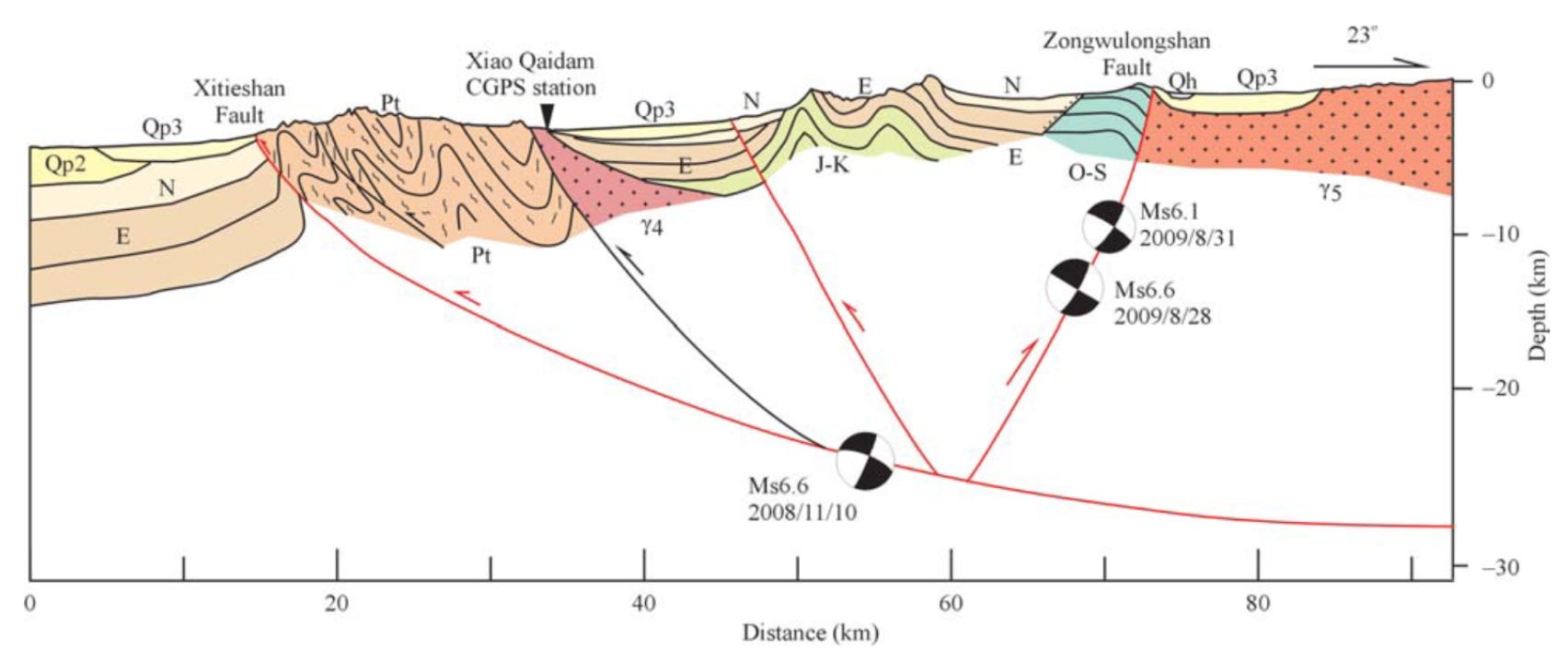
The recent earthquake occurred within the North Qaidam Thrust Belt — a set of thrust faults accommodate some of this shortening at the northeastern edge of the Tibetan Plateau. These faults are active: in fact, in 2008 and 2009, two earthquakes very similar to the recent one occurred nearby.
Although these earthquakes did not have a big societal impact, they received a lot of scientific attention. This is because the two earthquakes produced surprising surface deformation signals that were beautifully captured by radar satellites passing overhead before and after the earthquakes. These satellites are designed specifically to measure tiny changes in ground elevation, using a technique called Interferometric Synthetic Aperture Radar (InSAR). For more details on this method, see this post that we wrote following the 2023 M6.8 Morocco earthquake.
InSAR satellites broadcast a specially designed periodic RADAR signal toward Earth’s surface, and monitor the reflection of that signal back to the satellite. For each small patch of ground falling within the beam (basically, the pixels on the resulting image), the satellite records the phase of the returned wave. On the image below, the wavelength is marked as 24 centimeters, but the actual wavelength depends on the satellite. InSAR wavelengths typically range from ~3 centimeters to 24 centimeters.
Any motion of the ground toward or away from the satellite will cause a phase shift. If the movement is small enough, the differences all fall within a single wavelength, and we can just read off the line-of-sight displacement.
But there’s a problem: if the difference is more than one wavelength (or actually, more than one-half the wavelength, because the positive and negative parts of the waveform look the same), then the phase difference starts to repeat as different cycles of the reflected signal are recorded. To solve this, InSAR isn’t just a single measurement at one point, but is represented as a map. Because pixels that are near each other aren’t expected to have moved a lot relative to each other, it is possible (hopefully) to map out the continuous change in ground surface elevation from a location far away from the earthquake (where nothing moved) into the area that was deformed, without losing track of the total offset.
The Qaidam basin is an excellent place for InSAR because the arid environment means few plants on the surface and low water vapor content in the atmosphere. This means that the reflected signal is extremely coherent, allowing mapping of surface deformation with few artifacts.
For the 2008/2009 sequence, this is what the InSAR looked like. Each of those rainbow bands is one cycle of the InSAR half-wavelength, which in this case represents 2.8 centimeters towards or away from the satellite.
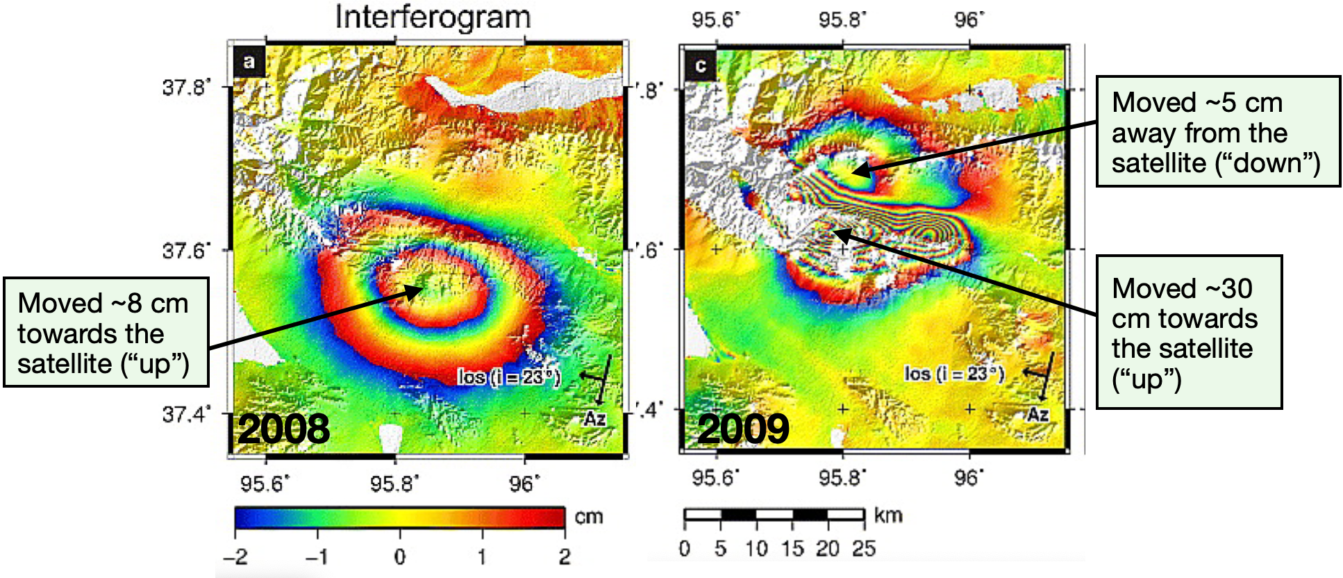
The two earthquakes were similar in magnitude (2008 M6.3, 2009 M6.2), and very close to each other, but their InSAR patterns were completely different. The first earthquake produced a single, broad, low-amplitude bulge. The second earthquake produced a much more concentrated, higher amplitude, irregular bulge — with more than three times as much uplift — with a paired area to the north with minor subsidence. The second earthquake was also located slightly to the north of the first earthquake. Puzzling!
Fortunately, a puzzle like this is just the kind of thing that makes for a good research paper, or two.
In 2011, J.R. Elliott and co-authors announced that they had an explanation. The two earthquakes, they said, had occurred on the same fault: a steep, south-dipping thrust fault. But the first earthquake had occurred on a deeper part of the fault. This was why the bulge was so broad: the surface signal was spread out by deformation of the intervening crust. This was important, they said, because it highlighted how different parts of a fault might rupture one after the other — meaning that earthquakes on the same fault might come as a one-two punch, potentially causing significant damage in a second round.
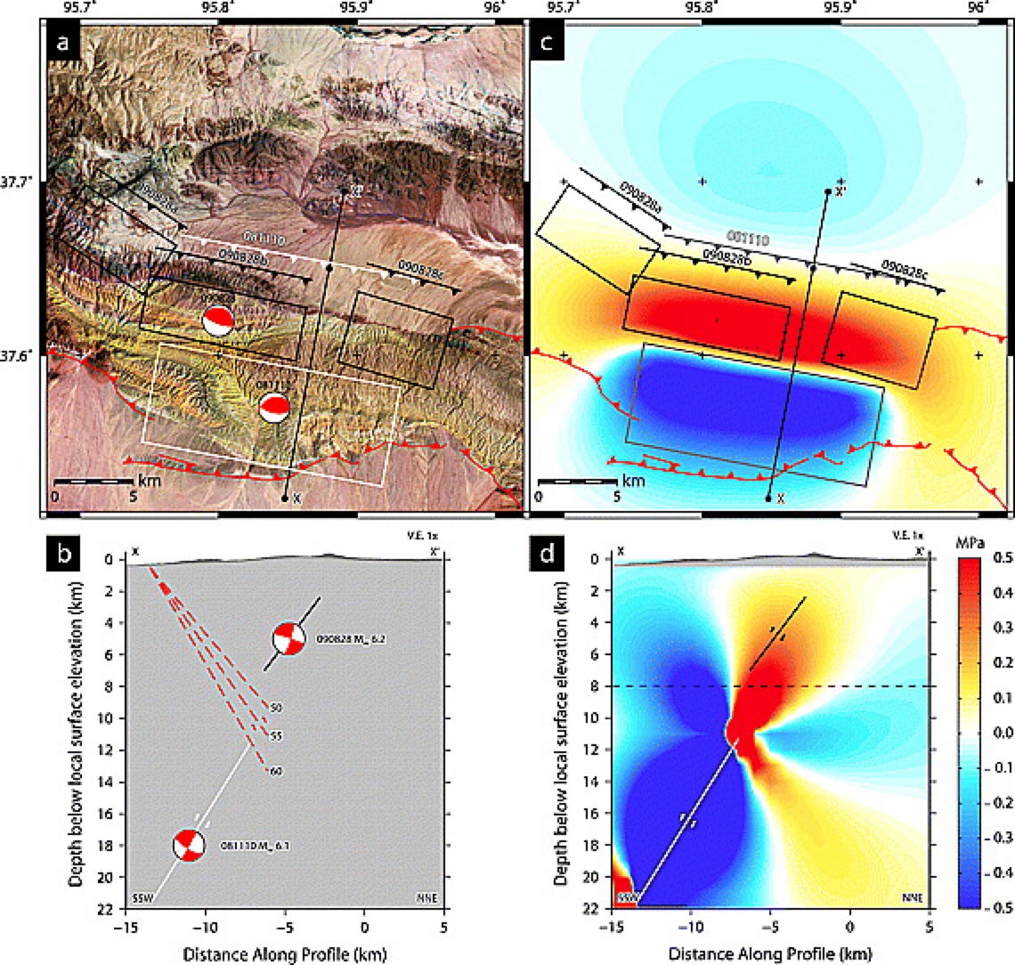
In 2013, G. Chen et al. contradicted this finding. They had different data: a nearby GPS station, plus careful investigations of the surface geology and geomorphology, which gave them insight into the faults below the surface. Furthermore, they had precisely relocated the aftershocks of the two earthquakes. These data showed that the interpretation of the 2009 earthquake was generally fine, but the 2008 earthquake had not been on a deep, south-dipping fault: instead it had occurred on a more gently dipping north-dipping fault. This was always the second option for the 2008 earthquake — the focal mechanism left open ambiguity about two possibilities.
This newly interpreted sequence illustrated how a fault system with forethrusts and backthrusts could have interacting earthquakes and stress fields.
The InSAR still made sense, because the 2008 earthquake had still occurred deeper, producing that broad, low-amplitude bulge.
(Other papers have also weighed in with their own interpretations, or looked at other data, like InSAR images of afterslip — the slower slip that sometimes occurs after an earthquake as the faults adjust to their new state.)
So, what does this all mean for the recent M6.3 earthquake ~30 kilometers to the northwest? Well, we expect to see a good InSAR signal that should provide an interesting basis for discussion. The COMET website indicates that there should have been a satellite flyover yesterday, so we can hope to (probably) see a new InSAR image very soon. (In some cases the data are not collected or are unusable, in which case we would need to wait another five days.) And perhaps people will be watching this event to see if it triggers a follow-on earthquake in the months to come. Typically, about 5-10% of earthquakes are followed by earthquakes of the same size or larger, so such an event would be fairly unsurprising (and definitely be a source of research projects!).
When we see a result with that data, we’ll drop a quick note here as an update. Check back if you’re interested!
Bradley, K., Hubbard, J., 2025. Deadly M7.1 earthquake strikes Tibet. Earthquake Insights, https://doi.org/10.62481/70c739a9
Chen, G., Xu, X., Zhu, A., Zhang, X., Yuan, R., Klinger, Y., Mocquet, J.-M., 2013. Seismotectonics of the 2008 and 2009 Qaidam earthquakes and its implication for regional tectonics. Acta Geologica Sinica‐English Edition, 87(2), pp.618-628. https://doi.org/10.1111/1755-6724.12072
Daout, S., Steinberg, A., Isken, M.P., Heimann, S. and Sudhaus, H., 2020. Illuminating the spatio-temporal evolution of the 2008–2009 Qaidam earthquake sequence with the joint use of InSAR time series and teleseismic data. Remote Sensing, 12(17), p.2850. https://doi.org/10.3390/rs12172850
Elliott, J.R., Parsons, B., Jackson, J.A., Shan, X., Sloan, R.A. and Walker, R.T., 2011. Depth segmentation of the seismogenic continental crust: The 2008 and 2009 Qaidam earthquakes. Geophysical Research Letters, 38(6). https://doi.org/10.1029/2011GL046897
Hubbard, J. and Bradley, K., 2023. Did the High Atlas really grow 20 cm in the Moroccan earthquake?. Earthquake Insights, https://doi.org/10.62481/9cb23fd9
Kreemer, C., Blewitt, G. and Klein, E.C., 2014. A geodetic plate motion and Global Strain Rate Model. Geochemistry, Geophysics, Geosystems, 15(10), pp.3849-3889. https://doi.org/10.1002/2014GC005407
Zelenin, E., Bachmanov, D., Garipova, S., Trifonov, V. and Kozhurin, A., 2021. The database of the active faults of Eurasia (AFEAD): Ontology and design behind the continental-scale dataset. Earth System Science Data Discussions, 2021, pp.1-20. https://doi.org/10.5194/essd-14-4489-2022